Showing 1–12 of 20 results
-

A 16th century map of the colony of New Spain
£750ORTELIUS, Abraham.
Published In 1584
Stock No. 24448 -

An 18th century map of the Americas
£550EULER, Leonhard.
Published In 1753
Stock No. 24536 -

One of the earliest maps to depict America
£42,500WALDSEEMULLER, Martin.
Published In 1513
Stock No. 24130 -

The first atlas issue of this 17th century map of America
£2,200HONDIUS, Jodocus II.
Published In 1636
Stock No. 19628 -

Speed’s landmark map of America
£3,950SPEED, John.
Published In 1665
Stock No. 23980 -

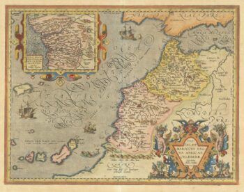
A 16th century map of Morocco
£700ORTELIUS, Abraham.
Published In 1601
Stock No. 23718 -

An account of the Texan Santa F? Expedition
£1,000KENDALL, George Wilkins.
Published In 1844
Stock No. 23853 -

A sought after map of the Republic of Texas
£1,200RADEFELD, Carl Christian Franz.
Published In 1846
Stock No. 23839 -

A superbly decorated map of the Americas
£6,500HONDIUS, Jodocus.
Published In 1628
Stock No. 23601 -

One of the few maps showing the Republic of Texas
£750KENDALL, George Wilkins.
Published In 1844
Stock No. 23325 -

The scarce second Galle plate for America used in the ‘Epitome’
£470ORTELIUS, Abraham.
Published In 1598
Stock No. 23190 -
The Fries edition of Wäldseemüller’s map of the Americas
£8,500WALDSEEMULLER, Martin.
Published In 1541
Stock No. 23045