- Reset all
- Argentina
- Bering Strait
- Burma
- Canada
- Canary Islands
- Devon
- Eastern Europe
- Elba
- France
- Georgia
- Gulf States
- Hertfordshire
- Holy Land
- Lancashire
- Latvia and Estonia
- Leinster
- Madeira
- Morocco
- Netherlands
- North America Maps
- Northamptonshire
- Nottinghamshire
- Prints
- Russia
- Solar System
- Trentino
- Ukraine
- United States
- Vietnam
- Westmorland
- World and Continents
- World Maps
Showing 505–516 of 533 results
-

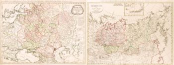
Two-sheet map of the Russian Empire
£1,200MANNERT, Konrad.
Published In 1794
Stock No. 11414 -

Holland with an Inset of its colonies in the East Indies
£280SEUTTER, Matthaus.
Published In 1744
Stock No. 11407 -

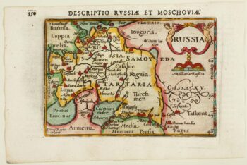
An early 17th century miniature map of Russia
£200BERTIUS, Petrus.
Published In 1603
Stock No. 11401 -

The first printed map of Corsica
£800BORDONE, Benedetto.
Published In 1534
Stock No. 11217 -

The English colonies on the north-east seaboard of America
£1,450HOMANN, Johann Baptist.
Published In 1725
Stock No. 11207 -

Cambrai in the C16th
£420BRAUN, Georg & HOGENBERG, Frans.
Published In 1596
Stock No. 11183 -

Miniature map of Holland
£140DU VAL, Pierre.
Published In 1682
Stock No. 10859 -

An impressive three-sheet map of the Russian Empire
£2,950TRESCOTT, John & SCHMIDT, Jakob.
Published In 1782
Stock No. 10643 -

Madeira
£150BELLIN, Jacques-Nicolas.
Published In 1746
Stock No. 10178 -

Virginia & Florida
£1,350BLAEU, Willem Janszoon.
Published In 1647
Stock No. 10145 -

France
£340AA, Pieter van der.
Published In 1715
Stock No. 9943 -

Early 18th century view of Paris
£580AA, Pieter van der.
Published In 1715
Stock No. 9942