- Reset all
- Atlases
- Azores
- Balearics
- Balkan maps
- Bolivia
- Buckinghamshire
- Burma
- Central Asia
- China
- Cyprus
- Devon
- Europe Continent
- Florida
- Germany
- Gibraltar
- Globes and Instruments
- Greece
- Gulf States
- Indonesia
- Ionian Islands
- Lancashire
- Latvia and Estonia
- London Localities
- Madagascar
- Malta
- Map Games
- Marche
- Maritime
- New York
- North America Maps
- Panama
- Pennsylvania
- Rutland
- Scottish Islands
- Southern Europe
- Suffolk
- Sussex
- Switzerland
- Tuscany
- Ukraine
- Ulster
- Umbria
- World
Showing 25–36 of 919 results
-

A late-18th century plan of Geneva
£250ANDREWS, John.
Published In 1800
Stock No. 24514 -

A late-18th century plan of Berlin
£260ANDREWS, John.
Published In 1800
Stock No. 24513 -

A plan of Puducherry at the beginning of the 18th century
£250FER, Nicolas de.
Published In 1705
Stock No. 24511 -

Miniature map of Cyprus and the islands of the Aegean
£350HONDIUS, Jodocus II.
Published In 1610
Stock No. 24510 -

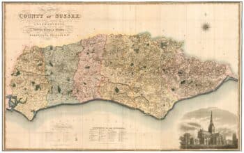
A large scale map of Sussex in fine colour
£2,800GREENWOOD, C. & J.
Published In 1825
Stock No. 24224 -

An extremely rare example of the first printed plan of Exeter
£4,500HOOKER, John.
Published In 1587
Stock No. 24437 -

Chelsea from an important large-scale survey of London
£1,500HORWOOD, Richard.
Published In 1799
Stock No. 24403 -

A map of Philadelphia as the capital of the Revolution
£3,400LOTTER, Matthaus Albrecht.
Published In 1777
Stock No. 24398 -

A pictorial map of Beijing in the 1930s
£3,000DORN, Frank.
Published In 1936
Stock No. 24392 -

A scarce Elizabethan plan of Westminster
£1,900NORDEN, John.
Published In 1593
Stock No. 24358 -
First issue of Rumold Mercator’s map of Europe
£2,500MERCATOR, Rumold.
Published In 1595
Stock No. 24298 -

One of the first maps to show Pakistan as an independent state
£2,500SURVEY OF PAKISTAN.
Published In 1950
Stock No. 24297