Showing 1–12 of 45 results
-

A late-18th century plan of Vienna
£230ANDREWS, John.
Published In 1800
Stock No. 24512 -

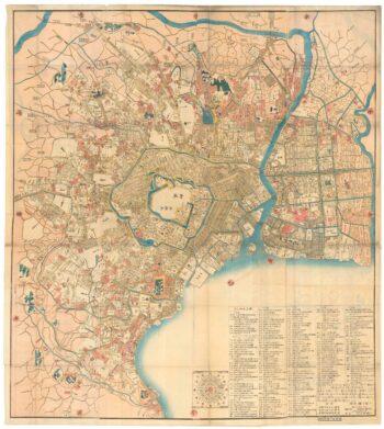
A Japanese woodblock wall map of Edo
£4,500TAKAI RANZAN.
Published In 1859
Stock No. 23071 -

A Jesuit missionary’s contribution to the mapping of Japan
£6,000CARDIM, Antonio Francisco.
Published In 1646
Stock No. 24221 -

A famous 16th century woodblock map of North Africa
£850WALDSEEMULLER, Martin.
Published In 1541
Stock No. 23837 -

Ortelius’s map of the province of Salzburg, in fine colour
£600ORTELIUS, Abraham.
Published In 1612
Stock No. 23808 -

A 17th century map of Austria
£350HONDIUS, Jodocus II.
Published In 1635
Stock No. 23746 -

Mid 19th century map of Austria and the Habsburg Empire
£160TALLIS, John.
Published In 1851
Stock No. 23497 -

The first state of the Tirion-Albrizzi map of Japan
£500TIRION, Isaak.
Published In 1734
Stock No. 23413 -

Scarce 17th century map of Japan
£650CLOPPENBURG, Johannes.
Published In 1630
Stock No. 23317 -
The scarce second Galle plate for Japan used in the ‘Epitome’
£300ORTELIUS, Abraham.
Published In 1598
Stock No. 23192 -

A 17th century map of Austria
£400JANSSON, Jan.
Published In 1650
Stock No. 20320 -

A fine early sea chart of Japan
£1,800JANSSON, Jan.
Published In 1658
Stock No. 22584