Showing 1–12 of 131 results
-

The first English atlas map of the Turkish Empire
£2,500SPEED, John.
Published In 1665
Stock No. 23981 -

One of the earliest versions of Sophianos’s map of Greece
£14,000BERTELLI, Ferrando
Published In 1564
Stock No. 24220 -

18th century map of the Persian Gulf
£450DELISLE DE SALES, Jean-Baptiste-Claude.
Published In 1770
Stock No. 22946 -

A decorative 18th century map of Greece
£500SEUTTER, Matthaus.
Published In 1750
Stock No. 22308 -

A large and decorative map of Corfu
£750CORONELLI, Vincenzo Maria.
Published In 1690
Stock No. 24095 -

The Genealogies of the Palaiologan Emperors and Ottoman Sultans
£950ROGG, Gottfried.
Published In 1755
Stock No. 23856 -

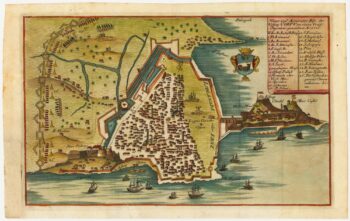
Rare town-plan of Corfu under siege by the Ottomans
£340WIERING, Thomas von.
Published In 1716
Stock No. 23665 -

An 18th century chart of Corfu
£110ROUX, Joseph.
Published In 1804
Stock No. 23636 -

Map of Ancient Greece by Ortelius, rare first printing
£1,000ORTELIUS, Abraham.
Published In 1587
Stock No. 23549 -

Map of the Ottoman Empire with decorative vignettes
£150TALLIS, John.
Published In 1851
Stock No. 23499 -

Decorative map of Sweden and Norway
£160TALLIS, John.
Published In 1851
Stock No. 23485 -
18th century plan of Paris in the decade before the French Revolution
£850ALIBERT, Jean.
Published In 1780
Stock No. 23420