Showing 1–12 of 36 results
-

A view of the Battle of Lepanto engraved in 1572
£2,500CAVALIERI, Giovanni Battista de'.
Published In 1647
Stock No. 24486 -

An instructional card explaining shipboard directions
£220Anonymous.
Published In 1840
Stock No. 24472 -

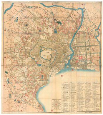
A Japanese woodblock wall map of Edo
£4,500TAKAI RANZAN.
Published In 1859
Stock No. 23071 -
The largest representation of Hawaii to appear in an atlas
£900VANDERMAELEN, Philippe.
Published In 1827
Stock No. 24396 -

A decorative marine print of early 18th century warships
£1,250HOMANN, Johann Baptist.
Published In 1730
Stock No. 24163 -

An 18th century maritime explanatory print
£1,200CHATELAIN, Henri Abraham.
Published In 1720
Stock No. 24154 -

18th century map of the Caspian Sea & Uzbekistan
£950MAAS, Abraham.
Published In 1735
Stock No. 24091 -

A Jesuit missionary’s contribution to the mapping of Japan
£6,000CARDIM, Antonio Francisco.
Published In 1646
Stock No. 24221 -

Decorative plate of an early 18th century warship
£1,400SEUTTER, Matthaus.
Published In 1730
Stock No. 24090 -

Six seascapes on one plate after an English artist
£900BASTON, Thomas.
Published In 1730
Stock No. 23923 -

Early 19th century table of maritime flags
£750ROSSI, Luigi.
Published In 1820
Stock No. 23465 -

The first state of the Tirion-Albrizzi map of Japan
£500TIRION, Isaak.
Published In 1734
Stock No. 23413