Showing 1–12 of 46 results
-

An 18th century ‘vue d’optique’ of Quebec
£750LEIZELT, Balthasar Frederick.
Published In 1775
Stock No. 24523 -

A very scarce Italian playing card of South America
£450Anonymous.
Published In 1790
Stock No. 24230 -

A French edition of an important map of the St Lawrence valley
£1,600CARVER, Jonathan.
Published In 1777
Stock No. 23477 -

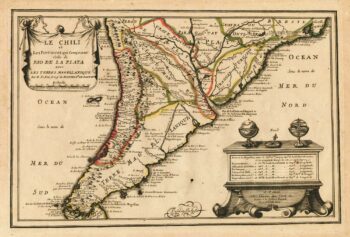
Map of Southern South America
£220FER, Nicolas de.
Published In 1702
Stock No. 23712 -

A mid 19th century map of West Canada with vignettes
£160TALLIS, John.
Published In 1851
Stock No. 23498 -

Map of Eastern Canada with vignettes
£150TALLIS, John.
Published In 1851
Stock No. 23482 -

A late 18th century map of Canada and the Great Lakes
£550ROBERT DE VAUGONDY, Didier.
Published In 1793
Stock No. 23279 -

An 18th century map of South America
£480CHATELAIN, Henri Abraham.
Published In 1718
Stock No. 23261 -
Sanson’s map of Canada with an early depiction of the Great Lakes
£4,750SANSON, Nicolas.
Published In 1662
Stock No. 23067 -

Classic early 17th century Dutch map of South America in fine colour
£1,400HONDIUS, Jodocus.
Published In 1633
Stock No. 22863 -

A detailed 18th century plan of the St Lawrence River
£420HARRISON, John.
Published In 1784
Stock No. 22812 -
A classic 16th century map of South America
£8,000LINSCHOTEN, Jan Huygen van.
Published In 1596
Stock No. 22752