Showing 1–12 of 24 results
-

An 18th century ‘vue d’optique’ of Quebec
£750LEIZELT, Balthasar Frederick.
Published In 1775
Stock No. 24523 -

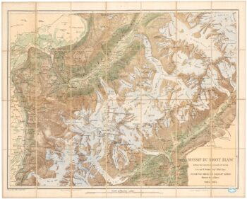
A detailed plan of the Mont-Blanc massif
£1,600BARBEY, Albert.
Published In 1924
Stock No. 22980 -

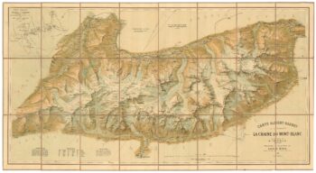
An important map of the Mont Blanc Massif
£950MIEULET, Jean-Joseph.
Published In 1865
Stock No. 24076 -

A French edition of an important map of the St Lawrence valley
£1,600CARVER, Jonathan.
Published In 1777
Stock No. 23477 -

A mid 19th century map of West Canada with vignettes
£160TALLIS, John.
Published In 1851
Stock No. 23498 -

Map of Eastern Canada with vignettes
£150TALLIS, John.
Published In 1851
Stock No. 23482 -

A late 18th century map of Canada and the Great Lakes
£550ROBERT DE VAUGONDY, Didier.
Published In 1793
Stock No. 23279 -

A scarce 17th century prospect of Saint-Jean-de-Maurienne in superb colour
£400BLAEU, Johannes.
Published In 1682
Stock No. 23269 -

17th century chart of Patagonia
£1,250DE WIT, Frederick.
Published In 1680
Stock No. 23154 -
Sanson’s map of Canada with an early depiction of the Great Lakes
£4,750SANSON, Nicolas.
Published In 1662
Stock No. 23067 -

A detailed 18th century plan of the St Lawrence River
£420HARRISON, John.
Published In 1784
Stock No. 22812 -

A plan of the British attack on Quebec in October 1690 by a defender
£550LAHONTAN, Louis-Armande de.
Published In 1741
Stock No. 22562