Showing 1–12 of 361 results
-

The First Edition of Ortelius’s map of the Spice Islands
£4,000ORTELIUS, Abraham.
Published In 1570
Stock No. 24431 -

Victorian map of China with views of Hong Kong and Canton
£250TALLIS, John.
Published In 1851
Stock No. 23537 -

Chart of the Planetary System
£175BLUNT, Charles F.
Published In 1845
Stock No. 24250 -

A pictorial map of Beijing in the 1930s
£3,000DORN, Frank.
Published In 1936
Stock No. 24392 -

The map of China from the first English atlas of the world
£3,700SPEED, John.
Published In 1665
Stock No. 23978 -

19th century Spanish sea chart of the Yellow Sea and Korea
£2,200BRYANT, Tomas.
Published In 1866
Stock No. 12450 -

A 19th century American sea chart of Hong Kong
£3,500BREWER, H.G.
Published In 1916
Stock No. 23973 -

A detailed map of Victoria in the 1930s
£4,500WAR OFFICE.
Published In 1930
Stock No. 23458 -

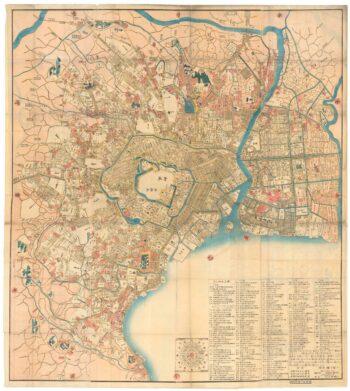
A Japanese woodblock wall map of Edo
£4,500TAKAI RANZAN.
Published In 1859
Stock No. 23071 -

The iconic depiction of the Copernican solar system
£5,000CELLARIUS, Andreas.
Published In 1708
Stock No. 24383 -

18th century English map of the East Indies
£440BOWEN, Emanuel.
Published In 1752
Stock No. 21763 -

Chart of the Sun
£175BLUNT, Charles F.
Published In 1845
Stock No. 24357