Showing 1–12 of 203 results
-

A political map of the Partition of British India
£1,800BUREAU OF CURRENT AFFAIRS.
Published In 1949
Stock No. 24485 -

Gwynn’s proposed improvements between modern Moorgate and Bank.
£300GWYNN, John
Published In 1766
Stock No. 24084 -

A two-sheet map of North America
£2,950JAILLOT, Alexis-Hubert.
Published In 1705
Stock No. 24062 -

A two-sheet map of North America
£2,250JAILLOT, Alexis-Hubert.
Published In 1674
Stock No. 24482 -

A late 18th century map of India.
£700MANNERT, Konrad.
Published In 1797
Stock No. 24481 -

A plan of Puducherry at the beginning of the 18th century
£250FER, Nicolas de.
Published In 1705
Stock No. 24511 -

Chelsea from an important large-scale survey of London
£1,500HORWOOD, Richard.
Published In 1799
Stock No. 24403 -

A scarce Elizabethan plan of Westminster
£1,900NORDEN, John.
Published In 1593
Stock No. 24358 -

One of the first maps to show Pakistan as an independent state
£2,500SURVEY OF PAKISTAN.
Published In 1950
Stock No. 24297 -

A rare Italian edition of Hennepin’s landmark map of Louisiana
£2,800HENNEPIN, Louis.
Published In 1691
Stock No. 24027 -

A large and detailed map of India
£1,500WALKER, J. & C.
Published In 1844
Stock No. 24341 -

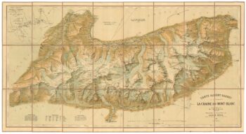
A detailed plan of the Mont-Blanc massif
£1,600BARBEY, Albert.
Published In 1924
Stock No. 22980