Showing 1–12 of 70 results
-

The first English atlas map of the Turkish Empire
£2,500SPEED, John.
Published In 1665
Stock No. 23981 -

18th century map of the Persian Gulf
£450DELISLE DE SALES, Jean-Baptiste-Claude.
Published In 1770
Stock No. 22946 -

The Genealogies of the Palaiologan Emperors and Ottoman Sultans
£950ROGG, Gottfried.
Published In 1755
Stock No. 23856 -

The famous map of Leinster by John Speed
£750SPEED, John.
Published In 1665
Stock No. 23786 -

Map of the Ottoman Empire with decorative vignettes
£150TALLIS, John.
Published In 1851
Stock No. 23499 -

Early 18th century map of the Ottoman Empire and Persia
£240FER, Nicolas de.
Published In 1705
Stock No. 23242 -

Early map of the roads from Lichfield to Chester
£280OGILBY, John.
Published In 1675
Stock No. 23239 -

Sea chart of south east Ireland with an inset of Dublin Bay
£550SELLER, Jeremiah.
Published In 1750
Stock No. 23160 -

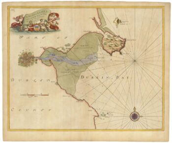
Sea chart of Dublin Bay from the first English sea-atlas
£550COLLINS, Greenvile.
Published In 1693
Stock No. 23156 -

Miniature map of Longford and West Meath
£100PERROT, Aristide Michel.
Published In 1828
Stock No. 23127 -

Miniature map of East Meath
£110PERROT, Aristide Michel.
Published In 1828
Stock No. 23126 -

Miniature map of Dublin
£110PERROT, Aristide Michel.
Published In 1828
Stock No. 23125