Showing 1–12 of 99 results
-

A serio-comic map of Europe with the Russian octopus
£4,750GROSSI, Augusto.
Published In 1878
Stock No. 24393 -

A caricature of Churchill as an octopus, produced for occupied France
£1,000S.P.K.
Published In 1942
Stock No. 24106 -

The first English atlas map of the Turkish Empire
£2,500SPEED, John.
Published In 1665
Stock No. 23981 -

The Salvation Army’s vision of a new Utopia
£250BOOTH, William.
Published In 1890
Stock No. 24450 -

A French serio-comic map of Europe for the Great War
£1,850CRETE, B.
Published In 1915
Stock No. 23347 -

An Air France poster map of the world in a double hemisphere
£1,900BOUCHER, Lucien.
Published In 1950
Stock No. 23336 -

18th century map of the Persian Gulf
£450DELISLE DE SALES, Jean-Baptiste-Claude.
Published In 1770
Stock No. 22946 -

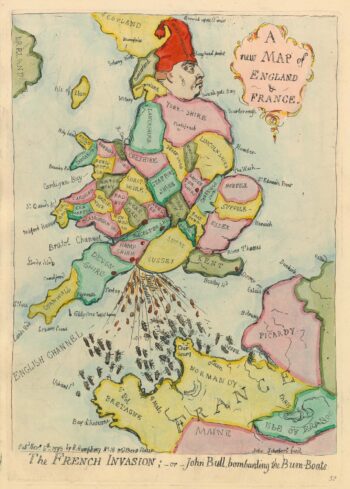
Caricature map of England in danger of invasion, from Gillray’s cruder output
£1,250GILLRAY, James.
Published In 1851
Stock No. 24158 -

The Genealogies of the Palaiologan Emperors and Ottoman Sultans
£950ROGG, Gottfried.
Published In 1755
Stock No. 23856 -

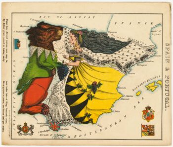
A satirical map of Spain & Portugal
£500ALEPH [HARVEY, William].
Published In 1869
Stock No. 23755 -

A satirical map of Holland & Belgium
£500ALEPH [HARVEY, William].
Published In 1869
Stock No. 23754 -

An allegorical map of map of England
£750ALEPH [HARVEY, William].
Published In 1869
Stock No. 23751